


By Ramona Flightner/ @ramonaflightner
As I wrote recently, I love research. One of my favorite things is talking with others about my research or finding someone else who is knowledgeable about something that interests me. While I was at the West End Museum a few weeks ago, I met a man there who knew a lot about Boston history and the evolution of the transportation system. He had created some of the maps that were used in the museum and he eagerly (or at least, happily) answered my questions about the area near the West End where Canal Street is today.
If you’ve been reading my blog, you know about the “re-development” project that occurred in Boston in the 1950’s and the destruction of the old West End neighborhood. However, a small area near where the Boston Garden and North Station stands remains with numerous old buildings. I had always wondered why it wasn’t torn down and what part of the city it was part of. Was it part of the North End since it wasn’t torn down with the West End?
Map of Boston in 1775- from the Boston Redevelopment Authority
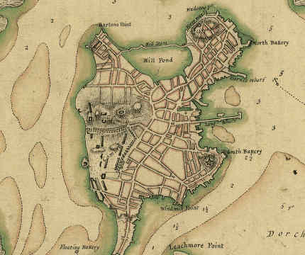
Enter my new friend who loves maps and transportation, and me, who loves to study old maps and understand the evolution of a city. At the reception for ropewalking, there were numerous pictures of old maps of Boston. It was explained to me that the area that now consists of Canal Street and the area near North Station, used to be an old tidal wetland and mill pond. However, Bostonians were always savvy, and knew that they would earn more money from a real estate venture than from a few mill ponds. They gave permission to Charles Bulfinch, one of the first men in America to practice architecture as a profession, to fill in the old mill-pond. He used the excavated dirt from the top of Beacon Hill (which used to be twice as tall as it is now), to fill the pond. When it had been filled, they left a small canal of the now filled in area where canal boats could be dragged and unloaded. (Here is a link to a map of Boston in 1836- the Back bay has yet to be filled in.http://maps.bpl.org/id/m8637 ) The canal connected Middlesex Canal across the Charles River in Charlestown to Boston’s waterfront. However, the life expectancy of a canal was short with the invention of the railroad. The canal was eventually filled in, the railroads moved in, and all major shipping was transferred to the harbor. The canal was in existence until 1845.
Thus, Canal Street really was a canal.